

Bloomberg’s interactive map of US oil rigs shows decline across the country
Tuesday, March 1, 2016

Bloomberg published an interactive map of U.S. shale oilfields that shows the decline in rigs in all U.S. shale plays over the past five years. The map’s views can switch between counties and states as well as rig types.
Figures for total rig counts, oil prices and domestic crude production are also included in the data.
According to Bloomberg, the rig count is close to its lowest level since Baker Hughes began to keep rig count records in 1940.
Read more: Bloomberg > Watch five years of oil drilling collapse in seconds
Leave a Comment
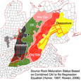
Marcellus & Utica Shale Well Map
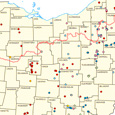
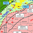
Additional Shale Maps
Shale FAQ
How often do royalty payments come?
Depending on the company, royalty payments can arrive monthly or quarterly.
Are my royalty payments transferable?
Yes. If you plan on selling your property, notify the gas company that is leasing your land and your realtor. They will make arrangements to allow the royalty payments to transfer to a different land owner.
What are royalties?
Royalties are payments from the gas company to the landowner as part of a lease agreement. Royalties payments cannot begin until production begins. The payments are dependent upon the market price of the resource.